


Maubois, Col de L'Evêque, Sommet Uzel, Pic de l'Ours, Pic d'Aurelle retour 3544 ET

verotrail
User
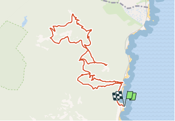

Length
14.8 km

Max alt
486 m

Uphill gradient
574 m
Km-Effort
22 km

Min alt
16 m

Downhill gradient
573 m
Boucle
Yes
Creation date :
2021-11-06 09:23:28.601
Updated on :
2022-01-04 17:05:58.177
5h05
Difficulty : Medium

FREE GPS app for hiking
 SityTrail
IGN / Geographical institutes
SityTrail Plus
The world is yours!
About
Trail On foot of 14.8 km to be discovered at Provence-Alpes-Côte d'Azur, Var, Saint-Raphaël. This trail is proposed by verotrail.
Positioning
Country:
France
Region :
Provence-Alpes-Côte d'Azur
Department/Province :
Var
Municipality :
Saint-Raphaël
Location:
Unknown
Start:(Dec)
Start:(UTM)
331832 ; 4813495 (32T) N.
Comments