


06/11/21
© OpenStreetMap contributors


2h04
Difficulty : Difficult


Length
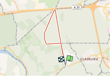
11 km
Max alt
401 m
Uphill gradient
167 m
Km-Effort
13.2 km
Min alt
308 m
Downhill gradient
169 m
Boucle
Yes
Creation date :
2021-11-06 13:25:12.142
Updated on :
2021-11-06 15:30:39.358
2h04
Difficulty : Difficult
FREE GPS app for hiking
 SityTrail
IGN / Geographical institutes
SityTrail Plus
The world is yours!
About
Trail Walking of 11 km to be discovered at Grand Est, Meurthe-et-Moselle, Chaligny. This trail is proposed by jerome-dupont@laposte.net.
Description
marche rapide mais.forest.- six bornes-autoroute direct
Positioning
Country:
France
Region :
Grand Est
Department/Province :
Meurthe-et-Moselle
Municipality :
Chaligny
Location:
Unknown
Start:(Dec)
Start:(UTM)
285339 ; 5392766 (32U) N.
Comments