


Dombasle _6km _ZI les Sables

ZAMBAUX
User
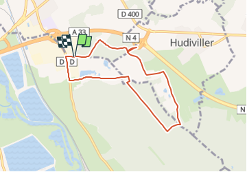

Length
6.8 km

Max alt
250 m

Uphill gradient
64 m
Km-Effort
7.7 km

Min alt
222 m

Downhill gradient
64 m
Boucle
Yes
Creation date :
2021-11-06 17:40:58.145
Updated on :
2023-03-17 08:57:14.401
58m
Difficulty : Easy

FREE GPS app for hiking
 SityTrail
IGN / Geographical institutes
SityTrail Plus
The world is yours!
About
Trail Walking of 6.8 km to be discovered at Grand Est, Meurthe-et-Moselle, Dombasle-sur-Meurthe. This trail is proposed by ZAMBAUX.
Description
Rando très facile
Positioning
Country:
France
Region :
Grand Est
Department/Province :
Meurthe-et-Moselle
Municipality :
Dombasle-sur-Meurthe
Location:
Unknown
Start:(Dec)
Start:(UTM)
305758 ; 5386437 (32U) N.
Comments