


Kalmthout

Veroz
User
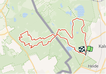

Length
22 km

Max alt
32 m

Uphill gradient
155 m
Km-Effort
24 km

Min alt
12 m

Downhill gradient
154 m
Boucle
Yes
Creation date :
2021-11-07 09:08:24.803
Updated on :
2021-11-07 15:04:31.436
5h17
Difficulty : Very easy

FREE GPS app for hiking
 SityTrail
IGN / Geographical institutes
SityTrail Plus
The world is yours!
About
Trail Walking of 22 km to be discovered at Flanders, Antwerp, Kalmthout. This trail is proposed by Veroz.
Positioning
Country:
Belgium
Region :
Flanders
Department/Province :
Antwerp
Municipality :
Kalmthout
Location:
Unknown
Start:(Dec)
Start:(UTM)
600845 ; 5692691 (31U) N.
Comments
Magnifique randonnée entre la Belgique et la Hollande. Paysages variés entre dunes et forêt. On se croirait presque dans la savane. A faire!!!