


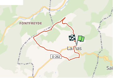
Larnas 6,5km

thonyc
User GUIDE

Length
6.6 km

Max alt
347 m

Uphill gradient
121 m
Km-Effort
8.2 km

Min alt
294 m

Downhill gradient
121 m
Boucle
Yes
Creation date :
2021-11-08 10:45:14.37
Updated on :
2021-11-08 11:02:45.246
1h51
Difficulty : Medium

FREE GPS app for hiking
 SityTrail
IGN / Geographical institutes
SityTrail Plus
The world is yours!
About
Trail Walking of 6.6 km to be discovered at Auvergne-Rhône-Alpes, Ardèche, Larnas. This trail is proposed by thonyc.
Positioning
Country:
France
Region :
Auvergne-Rhône-Alpes
Department/Province :
Ardèche
Municipality :
Larnas
Location:
Unknown
Start:(Dec)
Start:(UTM)
627301 ; 4922999 (31T) N.
Comments