Chateau de Montlosier puy de Lassolas Puy de la Vache Puy de vichatel 12km

jeanic63
User
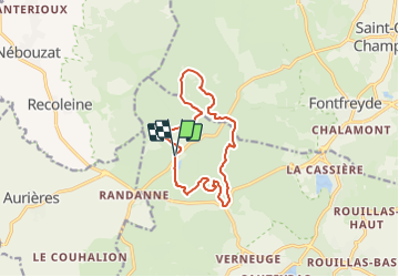

Length
11.9 km

Max alt
1174 m

Uphill gradient
451 m
Km-Effort
17.9 km

Min alt
952 m

Downhill gradient
447 m
Boucle
Yes
Creation date :
2021-11-08 17:45:12.65
Updated on :
2021-11-08 17:54:21.107
3h34
Difficulty : Medium

FREE GPS app for hiking
 SityTrail
IGN / Geographical institutes
SityTrail Plus
The world is yours!
About
Trail On foot of 11.9 km to be discovered at Auvergne-Rhône-Alpes, Puy-de-Dôme, Aydat. This trail is proposed by jeanic63.
Description
départ chateau de Montlosier
Positioning
Country:
France
Region :
Auvergne-Rhône-Alpes
Department/Province :
Puy-de-Dôme
Municipality :
Aydat
Location:
Unknown
Start:(Dec)
Start:(UTM)
496212 ; 5059997 (31T) N.
Comments