


Maisons Laffitte - Mont Valérien

sebastienu
User
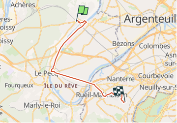

Length
18 km

Max alt
134 m

Uphill gradient
228 m
Km-Effort
21 km

Min alt
16 m

Downhill gradient
146 m
Boucle
No
Creation date :
2021-11-11 00:05:01.83
Updated on :
2021-11-11 01:03:13.406
4h42
Difficulty : Very difficult

FREE GPS app for hiking
 SityTrail
IGN / Geographical institutes
SityTrail Plus
The world is yours!
About
Trail Walking of 18 km to be discovered at Ile-de-France, Yvelines, Maisons-Laffitte. This trail is proposed by sebastienu.
Description
Marche du 13 novembre 2021

Positioning
Country:
France
Region :
Ile-de-France
Department/Province :
Yvelines
Municipality :
Maisons-Laffitte
Location:
Unknown
Start:(Dec)
Start:(UTM)
437381 ; 5421767 (31U) N.
Comments
Urbain et anti-pass