Trail Other activity Saint-Paul-en-Gâtine - rando telethon  - Photo
 favraux
favraux

User

© OpenStreetMap contributors
Length
Length
34 km
Max alt
Max alt
258 m
Uphill gradient
Uphill gradient
561 m
Km-Effort
Km-Effort  
42 km
Min alt
Min alt
67 m
Downhill gradient
Downhill gradient
636 m
Boucle
Boucle
No
Creation date :
2021-11-11 14:50:05.682
Updated on :
2021-11-11 16:19:13.617

(0 Reviews)

Other activity
Other activity
1h28
Difficulty : Very easy

Scan this QR Code to open this trail in the SityTrail application

FREE GPS app for hiking

Logo SityTrail SityTrail

IGN / Geographical institutes

Download SityTrail from the App Store Download SityTrail from Google Play

Logo SityTrail SityTrail World

The world is yours!

Download SityTrail from the App Store Download SityTrail from Google Play Download SityTrail on Huawei AppGallery

About

Trail Other activity of 34 km to be discovered at New Aquitaine, Deux-Sèvres, Saint-Paul-en-Gâtine. This trail is proposed by favraux.

Elevation profile

Positioning

Country:
France
Region :
New Aquitaine
Department/Province :
Deux-Sèvres
Municipality :
Saint-Paul-en-Gâtine
Location:
Unknown
Start:(UTM)
681530 ; 5167569 (30T) N.

Trails nearby

Trail Quad Loge-Fougereuse - FABRICE GERARD-DUBORD - Photo
Quad
favraux

Quad

Very easy
(1)
Loge-Fougereuse, Pays de la Loire, Vendée, France
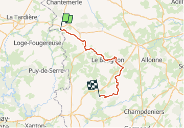
78 km | 91 km-effort
Unknown
Yes
Trail On foot La Chapelle-aux-Lys - Chemin aux Étoiles - L'histoire de l'Univers - Photo
On foot
PRO

On foot

Easy
La Chapelle-aux-Lys, Pays de la Loire, Vendée, France
4.3 km | 5.3 km-effort
1h 12min
No
Trail Walking Moncoutant-sur-Sèvre - Rando 17km A-R de la forêt de l'aventure - Photo
Walking
dudu79

Walking

Very difficult
(1)
Moncoutant-sur-Sèvre, New Aquitaine, Deux-Sèvres, France
17.5 km | 21 km-effort
4h 50min
Yes
Trail Walking Moncoutant-sur-Sèvre - La Bonneliere - Photo
Walking
Bushiben

Walking

Very easy
Moncoutant-sur-Sèvre, New Aquitaine, Deux-Sèvres, France
12.4 km | 14.2 km-effort
4h 59min
Yes
Trail Walking Moncoutant-sur-Sèvre - Chante merle - Photo
Walking
viaul

Walking

Easy
Moncoutant-sur-Sèvre, New Aquitaine, Deux-Sèvres, France
12.2 km | 14 km-effort
3h 4min
Yes
Trail Walking Moncoutant-sur-Sèvre - Forêt de l aventure  - Photo
Walking
viaul

Walking

Easy
Moncoutant-sur-Sèvre, New Aquitaine, Deux-Sèvres, France
19.8 km | 23 km-effort
5h 31min
Yes
Trail On foot Moncoutant-sur-Sèvre - rando du 23 mai 2021 - Photo
On foot
dudu79

On foot

Medium
Moncoutant-sur-Sèvre, New Aquitaine, Deux-Sèvres, France
21 km | 26 km-effort
5h 54min
Yes
Trail On foot Breuil-Barret - Boucle de Mélusine - Breuil Barret. - Photo
On foot
dudu79

On foot

Very difficult
Breuil-Barret, Pays de la Loire, Vendée, France
109 km | 130 km-effort
29h 30min
Yes
Trail Cycle Le Busseau - Guérinière Chantemerle - Photo
Cycle
Ceclm

Cycle

Very easy
Le Busseau, New Aquitaine, Deux-Sèvres, France
14.5 km | 17.8 km-effort
1h 0min
No


Close
My subscriptions