


12 - Brévent- lac du Brévent et retour

geranimo
User
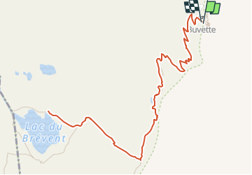

Length
3.9 km

Max alt
2502 m

Uphill gradient
347 m
Km-Effort
8.6 km

Min alt
2141 m

Downhill gradient
348 m
Boucle
Yes
Creation date :
2021-11-11 17:57:49.973
Updated on :
2022-06-06 22:46:33.535
3h04
Difficulty : Medium

FREE GPS app for hiking
 SityTrail
IGN / Geographical institutes
SityTrail Plus
The world is yours!
About
Trail Walking of 3.9 km to be discovered at Auvergne-Rhône-Alpes, Upper Savoy, Chamonix-Mont-Blanc. This trail is proposed by geranimo.
Positioning
Country:
France
Region :
Auvergne-Rhône-Alpes
Department/Province :
Upper Savoy
Municipality :
Chamonix-Mont-Blanc
Location:
Unknown
Start:(Dec)
Start:(UTM)
332360 ; 5088935 (32T) N.
Comments