


randounette entre banneux et adzeux

stef789
User GUIDE
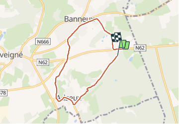

Length
6 km

Max alt
318 m

Uphill gradient
93 m
Km-Effort
7.2 km

Min alt
241 m

Downhill gradient
90 m
Boucle
No
Creation date :
2021-11-13 14:26:20.06
Updated on :
2021-11-13 15:51:15.866
1h24
Difficulty : Very easy

FREE GPS app for hiking
 SityTrail
IGN / Geographical institutes
SityTrail Plus
The world is yours!
About
Trail Walking of 6 km to be discovered at Wallonia, Liège, Sprimont. This trail is proposed by stef789.
Photos


Positioning
Country:
Belgium
Region :
Wallonia
Department/Province :
Liège
Municipality :
Sprimont
Location:
Louveigné
Start:(Dec)
Start:(UTM)
694857 ; 5601202 (31U) N.
Comments