


Meudon Val fleury- Bagneux

c.chehere
User
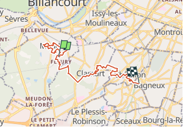

Length
13.1 km

Max alt
173 m

Uphill gradient
278 m
Km-Effort
16.7 km

Min alt
64 m

Downhill gradient
263 m
Boucle
No
Creation date :
2021-11-13 19:36:08.541
Updated on :
2022-08-21 17:24:08.782
3h36
Difficulty : Easy

FREE GPS app for hiking
 SityTrail
IGN / Geographical institutes
SityTrail Plus
The world is yours!
About
Trail Walking of 13.1 km to be discovered at Ile-de-France, Hauts-de-Seine, Meudon. This trail is proposed by c.chehere.
Description
De Meudon Val fleury à la limite bagneux fontenay
Positioning
Country:
France
Region :
Ile-de-France
Department/Province :
Hauts-de-Seine
Municipality :
Meudon
Location:
Unknown
Start:(Dec)
Start:(UTM)
444321 ; 5406352 (31U) N.
Comments