


Amicale_Boucle_Pollionnay_8_9

d.rognon
User
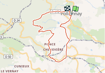

Length
8.9 km

Max alt
649 m

Uphill gradient
327 m
Km-Effort
13.3 km

Min alt
381 m

Downhill gradient
327 m
Boucle
Yes
Creation date :
2021-11-14 13:51:56.714
Updated on :
2022-02-26 19:39:50.104
3h00
Difficulty : Difficult

FREE GPS app for hiking
 SityTrail
IGN / Geographical institutes
SityTrail Plus
The world is yours!
About
Trail Walking of 8.9 km to be discovered at Auvergne-Rhône-Alpes, Rhône, Pollionnay. This trail is proposed by d.rognon.
Description
Rando très agréable qui avec temps clair permet de découvrir la chaîne du Mont Blanc
Positioning
Country:
France
Region :
Auvergne-Rhône-Alpes
Department/Province :
Rhône
Municipality :
Pollionnay
Location:
Unknown
Start:(Dec)
Start:(UTM)
629154 ; 5069297 (31T) N.
Comments