


Froises 16 kms

liebniz
User
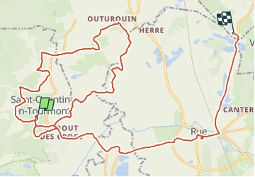

Length
29 km

Max alt
17 m

Uphill gradient
114 m
Km-Effort
31 km

Min alt
2 m

Downhill gradient
118 m
Boucle
No
Creation date :
2021-11-14 14:14:42.0
Updated on :
2021-11-14 17:39:24.884
2h31
Difficulty : Easy

FREE GPS app for hiking
 SityTrail
IGN / Geographical institutes
SityTrail Plus
The world is yours!
About
Trail Coupling of 29 km to be discovered at Hauts-de-France, Somme, Saint-Quentin-en-Tourmont. This trail is proposed by liebniz.
Positioning
Country:
France
Region :
Hauts-de-France
Department/Province :
Somme
Municipality :
Saint-Quentin-en-Tourmont
Location:
Unknown
Start:(Dec)
Start:(UTM)
399438 ; 5570298 (31U) N.
Comments