


2021_11_14

Atchoum26
User
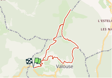

Length
10.5 km

Max alt
1443 m

Uphill gradient
860 m
Km-Effort
22 km

Min alt
728 m

Downhill gradient
860 m
Boucle
Yes
Creation date :
2021-11-14 12:50:57.638
Updated on :
2021-11-15 09:26:44.315
3h33
Difficulty : Easy

FREE GPS app for hiking
 SityTrail
IGN / Geographical institutes
SityTrail Plus
The world is yours!
About
Trail Walking of 10.5 km to be discovered at Auvergne-Rhône-Alpes, Drôme, Valouse. This trail is proposed by Atchoum26.
Description
Rando sympa et tranquille sans difficultée apparente. Sous le soleil. Possibilité de voir des chamois
Photos


Positioning
Country:
France
Region :
Auvergne-Rhône-Alpes
Department/Province :
Drôme
Municipality :
Valouse
Location:
Unknown
Start:(Dec)
Start:(UTM)
673085 ; 4925478 (31T) N.
Comments