


Antraïgues Le Mazoyer 14km

thonyc
User GUIDE
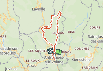

Length
14.3 km

Max alt
904 m

Uphill gradient
554 m
Km-Effort
22 km

Min alt
458 m

Downhill gradient
560 m
Boucle
Yes
Creation date :
2021-11-15 12:55:49.332
Updated on :
2022-05-03 11:28:18.766
4h56
Difficulty : Medium

FREE GPS app for hiking
 SityTrail
IGN / Geographical institutes
SityTrail Plus
The world is yours!
About
Trail Walking of 14.3 km to be discovered at Auvergne-Rhône-Alpes, Ardèche, Vallées-d'Antraigues-Asperjoc. This trail is proposed by thonyc.
Positioning
Country:
France
Region :
Auvergne-Rhône-Alpes
Department/Province :
Ardèche
Municipality :
Vallées-d'Antraigues-Asperjoc
Location:
Antraigues-sur-Volane
Start:(Dec)
Start:(UTM)
607556 ; 4952718 (31T) N.
Comments