


messin

Nila81
User
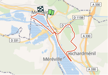

Length
7.2 km

Max alt
269 m

Uphill gradient
68 m
Km-Effort
8.1 km

Min alt
214 m

Downhill gradient
70 m
Boucle
Yes
Creation date :
2021-11-15 13:21:38.933
Updated on :
2021-11-15 15:17:58.169
1h55
Difficulty : Medium

FREE GPS app for hiking
 SityTrail
IGN / Geographical institutes
SityTrail Plus
The world is yours!
About
Trail Walking of 7.2 km to be discovered at Grand Est, Meurthe-et-Moselle, Messein. This trail is proposed by Nila81.
Description
avec remy
Positioning
Country:
France
Region :
Grand Est
Department/Province :
Meurthe-et-Moselle
Municipality :
Messein
Location:
Unknown
Start:(Dec)
Start:(UTM)
289879 ; 5387727 (32U) N.
Comments