


2021-11-15_18h58m44_volcan de Chirouse

Linerou
User
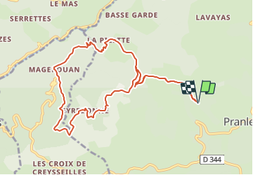

Length
11.5 km

Max alt
729 m

Uphill gradient
579 m
Km-Effort
19.2 km

Min alt
372 m

Downhill gradient
580 m
Boucle
Yes
Creation date :
2021-11-15 17:58:44.669
Updated on :
2021-11-20 18:44:20.827
4h21
Difficulty : Difficult

FREE GPS app for hiking
 SityTrail
IGN / Geographical institutes
SityTrail Plus
The world is yours!
About
Trail Walking of 11.5 km to be discovered at Auvergne-Rhône-Alpes, Ardèche, Pranles. This trail is proposed by Linerou.
Positioning
Country:
France
Region :
Auvergne-Rhône-Alpes
Department/Province :
Ardèche
Municipality :
Pranles
Location:
Unknown
Start:(Dec)
Start:(UTM)
623746 ; 4959175 (31T) N.
Comments