


2021-11-15_19h42m57_SityTrail - 2962158 - chaville-xmeudonxchaville-10x16km (2)

jpcccb
User
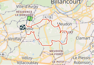

Length
14.2 km

Max alt
187 m

Uphill gradient
321 m
Km-Effort
18.5 km

Min alt
80 m

Downhill gradient
328 m
Boucle
No
Creation date :
2021-11-15 18:42:57.658
Updated on :
2023-05-02 14:32:18.963
4h11
Difficulty : Difficult

FREE GPS app for hiking
 SityTrail
IGN / Geographical institutes
SityTrail Plus
The world is yours!
About
Trail Walking of 14.2 km to be discovered at Ile-de-France, Hauts-de-Seine, Chaville. This trail is proposed by jpcccb.
Positioning
Country:
France
Region :
Ile-de-France
Department/Province :
Hauts-de-Seine
Municipality :
Chaville
Location:
Unknown
Start:(Dec)
Start:(UTM)
440416 ; 5406915 (31U) N.
Comments