


Montfleury_6km-8091097-1636998962-294

thonyc
User GUIDE
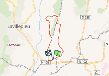

Length
5.6 km

Max alt
295 m

Uphill gradient
107 m
Km-Effort
7.1 km

Min alt
224 m

Downhill gradient
109 m
Boucle
Yes
Creation date :
2021-11-16 07:08:59.069
Updated on :
2021-11-16 07:14:39.389
2h00
Difficulty : Easy

FREE GPS app for hiking
 SityTrail
IGN / Geographical institutes
SityTrail Plus
The world is yours!
About
Trail Walking of 5.6 km to be discovered at Auvergne-Rhône-Alpes, Ardèche, Saint-Germain. This trail is proposed by thonyc.
Positioning
Country:
France
Region :
Auvergne-Rhône-Alpes
Department/Province :
Ardèche
Municipality :
Saint-Germain
Location:
Unknown
Start:(Dec)
Start:(UTM)
616886 ; 4935610 (31T) N.
Comments