


Montgey-novembre-2021

arnoultjf
User
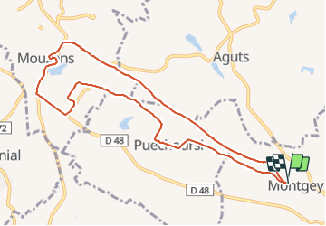

Length
10.8 km

Max alt
328 m

Uphill gradient
171 m
Km-Effort
13.1 km

Min alt
228 m

Downhill gradient
170 m
Boucle
Yes
Creation date :
2021-11-16 13:20:25.655
Updated on :
2021-11-16 17:20:54.57
2h34
Difficulty : Difficult

FREE GPS app for hiking
 SityTrail
IGN / Geographical institutes
SityTrail Plus
The world is yours!
About
Trail Walking of 10.8 km to be discovered at Occitania, Tarn, Montgey. This trail is proposed by arnoultjf.
Description
tbd
Photos


Positioning
Country:
France
Region :
Occitania
Department/Province :
Tarn
Municipality :
Montgey
Location:
Unknown
Start:(Dec)
Start:(UTM)
413699 ; 4818209 (31T) N.
Comments