


rando Varennes-Jarcy 14,7 km

jeanmarcMasson
User GUIDE
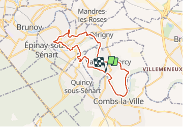

Length
14.7 km

Max alt
84 m

Uphill gradient
190 m
Km-Effort
17.3 km

Min alt
43 m

Downhill gradient
200 m
Boucle
Yes
Creation date :
2021-11-17 09:04:04.817
Updated on :
2021-11-17 13:46:08.01
3h43
Difficulty : Difficult

FREE GPS app for hiking
 SityTrail
IGN / Geographical institutes
SityTrail Plus
The world is yours!
About
Trail Walking of 14.7 km to be discovered at Ile-de-France, Essonne, Varennes-Jarcy. This trail is proposed by jeanmarcMasson.
Positioning
Country:
France
Region :
Ile-de-France
Department/Province :
Essonne
Municipality :
Varennes-Jarcy
Location:
Unknown
Start:(Dec)
Start:(UTM)
467350 ; 5391722 (31U) N.
Comments