


de

pjoly
User
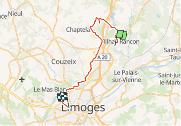

Length
21 km

Max alt
374 m

Uphill gradient
264 m
Km-Effort
25 km

Min alt
292 m

Downhill gradient
265 m
Boucle
No
Creation date :
2021-11-18 09:49:10.377
Updated on :
2021-11-18 11:24:31.636
1h27
Difficulty : Medium

FREE GPS app for hiking
 SityTrail
IGN / Geographical institutes
SityTrail Plus
The world is yours!
About
Trail Mountain bike of 21 km to be discovered at New Aquitaine, Haute-Vienne, Rilhac-Rancon. This trail is proposed by pjoly.
Description
scqvdv
Positioning
Country:
France
Region :
New Aquitaine
Department/Province :
Haute-Vienne
Municipality :
Rilhac-Rancon
Location:
Unknown
Start:(Dec)
Start:(UTM)
368737 ; 5083570 (31T) N.
Comments