


ST MARTIN - CADIERES A/R

Daniel Benteux
User
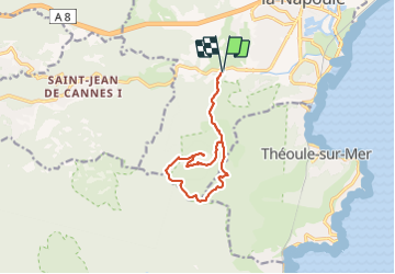

Length
11.4 km

Max alt
364 m

Uphill gradient
395 m
Km-Effort
16.6 km

Min alt
16 m

Downhill gradient
395 m
Boucle
Yes
Creation date :
2021-11-18 08:11:11.902
Updated on :
2021-11-18 13:42:31.602
3h21
Difficulty : Medium

FREE GPS app for hiking
 SityTrail
IGN / Geographical institutes
SityTrail Plus
The world is yours!
About
Trail Walking of 11.4 km to be discovered at Provence-Alpes-Côte d'Azur, Maritime Alps, Mandelieu-la-Napoule. This trail is proposed by Daniel Benteux.
Description
marche
Photos


Positioning
Country:
France
Region :
Provence-Alpes-Côte d'Azur
Department/Province :
Maritime Alps
Municipality :
Mandelieu-la-Napoule
Location:
Unknown
Start:(Dec)
Start:(UTM)
331177 ; 4821178 (32T) N.
Comments