


Fourche eu eau croix baguet haut des planches

audrey54
User
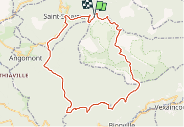

Length
21 km

Max alt
668 m

Uphill gradient
577 m
Km-Effort
28 km

Min alt
339 m

Downhill gradient
577 m
Boucle
Yes
Creation date :
2021-11-18 09:03:05.0
Updated on :
2021-11-18 13:51:22.409
4h25
Difficulty : Very difficult

FREE GPS app for hiking
 SityTrail
IGN / Geographical institutes
SityTrail Plus
The world is yours!
About
Trail Walking of 21 km to be discovered at Grand Est, Meurthe-et-Moselle, Saint-Sauveur. This trail is proposed by audrey54.
Positioning
Country:
France
Region :
Grand Est
Department/Province :
Meurthe-et-Moselle
Municipality :
Saint-Sauveur
Location:
Unknown
Start:(Dec)
Start:(UTM)
351832 ; 5377548 (32U) N.
Comments