


THEUX

fputters
User
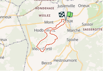

Length
9.9 km

Max alt
327 m

Uphill gradient
234 m
Km-Effort
13 km

Min alt
165 m

Downhill gradient
233 m
Boucle
Yes
Creation date :
2021-11-20 13:27:46.57
Updated on :
2021-11-20 13:33:01.937
2h52
Difficulty : Difficult

FREE GPS app for hiking
 SityTrail
IGN / Geographical institutes
SityTrail Plus
The world is yours!
About
Trail Walking of 9.9 km to be discovered at Wallonia, Liège, Theux. This trail is proposed by fputters.
Positioning
Country:
Belgium
Region :
Wallonia
Department/Province :
Liège
Municipality :
Theux
Location:
Theux
Start:(Dec)
Start:(UTM)
699201 ; 5601923 (31U) N.
Comments