


St Maurice d'Ardèche 7km

thonyc
User GUIDE
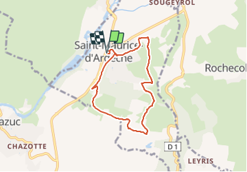

Length
6.7 km

Max alt
227 m

Uphill gradient
159 m
Km-Effort
8.8 km

Min alt
144 m

Downhill gradient
158 m
Boucle
Yes
Creation date :
2021-11-22 19:14:35.748
Updated on :
2021-11-22 19:37:39.106
2h30
Difficulty : Easy

FREE GPS app for hiking
 SityTrail
IGN / Geographical institutes
SityTrail Plus
The world is yours!
About
Trail Walking of 6.7 km to be discovered at Auvergne-Rhône-Alpes, Ardèche, Saint-Maurice-d'Ardèche. This trail is proposed by thonyc.
Positioning
Country:
France
Region :
Auvergne-Rhône-Alpes
Department/Province :
Ardèche
Municipality :
Saint-Maurice-d'Ardèche
Location:
Unknown
Start:(Dec)
Start:(UTM)
611195 ; 4930746 (31T) N.
Comments