


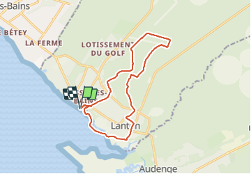
Cassy Port et Forêt puis Bassin baignade lanton

pierre.chaudat
User

Length
14.6 km

Max alt
30 m

Uphill gradient
94 m
Km-Effort
15.9 km

Min alt
-4 m

Downhill gradient
94 m
Boucle
Yes
Creation date :
2021-11-23 09:57:31.0
Updated on :
2021-11-23 15:42:54.545
4h27
Difficulty : Unknown

FREE GPS app for hiking
 SityTrail
IGN / Geographical institutes
SityTrail Plus
The world is yours!
About
Trail Walking of 14.6 km to be discovered at New Aquitaine, Gironde, Lanton. This trail is proposed by pierre.chaudat.
Positioning
Country:
France
Region :
New Aquitaine
Department/Province :
Gironde
Municipality :
Lanton
Location:
Unknown
Start:(Dec)
Start:(UTM)
653822 ; 4952517 (30T) N.
Comments