


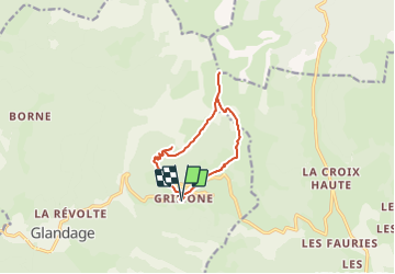
Grimone_Jocou-13975236-1637774062-179

thonyc
User GUIDE

Length
10.4 km

Max alt
2036 m

Uphill gradient
924 m
Km-Effort
23 km

Min alt
1109 m

Downhill gradient
926 m
Boucle
Yes
Creation date :
2021-11-24 17:17:11.266
Updated on :
2021-11-24 17:32:27.254
4h00
Difficulty : Very difficult

FREE GPS app for hiking
 SityTrail
IGN / Geographical institutes
SityTrail Plus
The world is yours!
About
Trail Walking of 10.4 km to be discovered at Auvergne-Rhône-Alpes, Drôme, Glandage. This trail is proposed by thonyc.
Description
Panoramas exceptionnels sur Vercors et Dévoluy.
Ne pas hésiter à faire l'aller-retour jusqu'au 2,5km ou même plus loin pour apprécier le vallon menant au col de Seysse.
Nota: pour randonneur averti
Positioning
Country:
France
Region :
Auvergne-Rhône-Alpes
Department/Province :
Drôme
Municipality :
Glandage
Location:
Unknown
Start:(Dec)
Start:(UTM)
708795 ; 4952522 (31T) N.
Comments