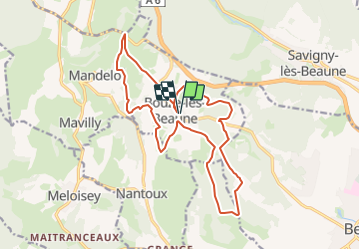
Bouze les Beaune Le sentier des Biques page 124

grasgilbert
User

Length
17.3 km

Max alt
522 m

Uphill gradient
404 m
Km-Effort
23 km

Min alt
338 m

Downhill gradient
405 m
Boucle
Yes
Creation date :
2021-11-25 08:25:20.474
Updated on :
2025-06-19 17:53:01.034
5h08
Difficulty : Very difficult

FREE GPS app for hiking
 SityTrail
IGN / Geographical institutes
SityTrail Plus
The world is yours!
About
Trail Walking of 17.3 km to be discovered at Bourgogne-Franche-Comté, Côte-d'Or, Bouze-lès-Beaune. This trail is proposed by grasgilbert.
Description
Pour aller voir la croix des roches sur un piton il faut aller et revenir le chemin est assez ennerbée
Positioning
Country:
France
Region :
Bourgogne-Franche-Comté
Department/Province :
Côte-d'Or
Municipality :
Bouze-lès-Beaune
Location:
Unknown
Start:(Dec)
Start:(UTM)
634654 ; 5212355 (31T) N.
Comments