


parcours_603197

c.chehere
User
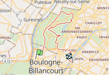

Length
15.1 km

Max alt
64 m

Uphill gradient
167 m
Km-Effort
17.3 km

Min alt
25 m

Downhill gradient
161 m
Boucle
No
Creation date :
2021-11-17 02:36:18.48
Updated on :
2021-11-28 09:16:52.091
3h54
Difficulty : Easy

FREE GPS app for hiking
 SityTrail
IGN / Geographical institutes
SityTrail Plus
The world is yours!
About
Trail Walking of 15.1 km to be discovered at Ile-de-France, Hauts-de-Seine, Boulogne-Billancourt. This trail is proposed by c.chehere.
Description
Du carrefour "Rhin et danube" (bus 126) à Boulogne au pont du Garigliano (T3)
Positioning
Country:
France
Region :
Ile-de-France
Department/Province :
Hauts-de-Seine
Municipality :
Boulogne-Billancourt
Location:
Unknown
Start:(Dec)
Start:(UTM)
443398 ; 5410058 (31U) N.
Comments