


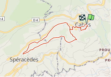
tour de Cabris

santaflor
User

Length
4.6 km

Max alt
556 m

Uphill gradient
187 m
Km-Effort
7.1 km

Min alt
396 m

Downhill gradient
190 m
Boucle
Yes
Creation date :
2021-11-28 09:19:08.668
Updated on :
2021-11-28 09:34:30.218
1h36
Difficulty : Medium

FREE GPS app for hiking
 SityTrail
IGN / Geographical institutes
SityTrail Plus
The world is yours!
About
Trail Walking of 4.6 km to be discovered at Provence-Alpes-Côte d'Azur, Maritime Alps, Cabris. This trail is proposed by santaflor.
Description
Depuis le pré, traverser le joli village de Cabris pour découvrir ses contreforts ,au milieu de la campagne méditerranéenne, orientés vers Spéracèdes et Peymeinade .
Positioning
Country:
France
Region :
Provence-Alpes-Côte d'Azur
Department/Province :
Maritime Alps
Municipality :
Cabris
Location:
Unknown
Start:(Dec)
Start:(UTM)
328776 ; 4835893 (32T) N.
Comments