


lMARAIS DE L'ENFER à St JORIOZ

COMAN
User
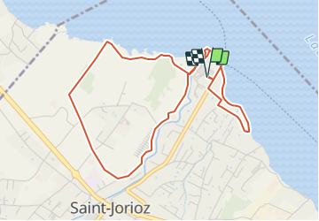

Length
5.3 km

Max alt
462 m

Uphill gradient
35 m
Km-Effort
5.8 km

Min alt
445 m

Downhill gradient
35 m
Boucle
Yes
Creation date :
2021-12-01 12:50:00.828
Updated on :
2021-12-01 12:55:35.651
1h18
Difficulty : Easy

FREE GPS app for hiking
 SityTrail
IGN / Geographical institutes
SityTrail Plus
The world is yours!
About
Trail Walking of 5.3 km to be discovered at Auvergne-Rhône-Alpes, Upper Savoy, Saint-Jorioz. This trail is proposed by COMAN.
Description
Petite randonnée dans le contournement du Marais de l'enfer à Saint Jorioz avec découverte de la plage et le port
Positioning
Country:
France
Region :
Auvergne-Rhône-Alpes
Department/Province :
Upper Savoy
Municipality :
Saint-Jorioz
Location:
Unknown
Start:(Dec)
Start:(UTM)
280514 ; 5080441 (32T) N.
Comments