


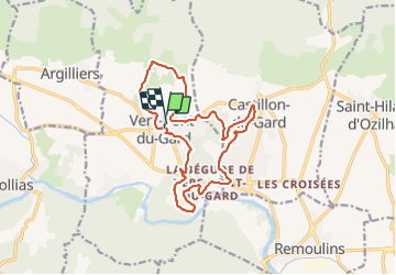
vers Pont du Gard Castillon

GOIOLIRIBES
User

Length
17 km

Max alt
100 m

Uphill gradient
216 m
Km-Effort
19.9 km

Min alt
27 m

Downhill gradient
213 m
Boucle
Yes
Creation date :
2021-12-02 08:33:56.287
Updated on :
2021-12-02 14:31:30.27
5h56
Difficulty : Very difficult

FREE GPS app for hiking
 SityTrail
IGN / Geographical institutes
SityTrail Plus
The world is yours!
About
Trail Walking of 17 km to be discovered at Occitania, Gard, Vers-Pont-du-Gard. This trail is proposed by GOIOLIRIBES.
Positioning
Country:
France
Region :
Occitania
Department/Province :
Gard
Municipality :
Vers-Pont-du-Gard
Location:
Unknown
Start:(Dec)
Start:(UTM)
622350 ; 4869338 (31T) N.
Comments