


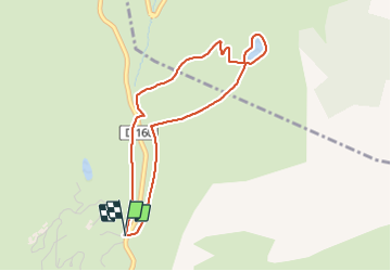
Retenue collinaire de l’Étale - n°4

UDGI54
User


--
Difficulty : Very easy

FREE GPS app for hiking
 SityTrail
IGN / Geographical institutes
SityTrail Plus
The world is yours!
About
Trail Snowshoes of 3.9 km to be discovered at Auvergne-Rhône-Alpes, Upper Savoy, Manigod. This trail is proposed by UDGI54.
Description
Randonnée au milieu des espaces préservés du col de Merdassier.
Accessibilité : Navette – arrêt Merdassier Caisses Centrales
Départ : Col de Merdassier
Située à 1500 m, la retenue collinaire de l’Étale a été créée en 2007 et dispose d’une capacité de 55 000 m3.


Positioning
Comments