


Le tour du mont Chauve d'Aspremont

franquen
User
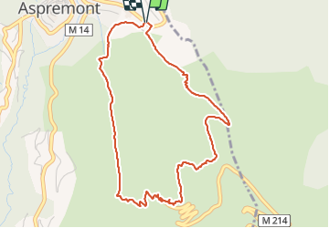

Length
5.2 km

Max alt
835 m

Uphill gradient
310 m
Km-Effort
9.3 km

Min alt
528 m

Downhill gradient
311 m
Boucle
Yes
Creation date :
2021-12-06 09:22:19.58
Updated on :
2021-12-06 15:46:01.52
2h31
Difficulty : Easy

FREE GPS app for hiking
 SityTrail
IGN / Geographical institutes
SityTrail Plus
The world is yours!
About
Trail Walking of 5.2 km to be discovered at Provence-Alpes-Côte d'Azur, Maritime Alps, Aspremont. This trail is proposed by franquen.
Positioning
Country:
France
Region :
Provence-Alpes-Côte d'Azur
Department/Province :
Maritime Alps
Municipality :
Aspremont
Location:
Unknown
Start:(Dec)
Start:(UTM)
359372 ; 4849175 (32T) N.
Comments