


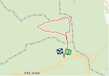
Trajet

UDGI54
User

Length
6.2 km

Max alt
1630 m

Uphill gradient
237 m
Km-Effort
9.3 km

Min alt
1473 m

Downhill gradient
234 m
Boucle
Yes
Creation date :
2021-12-06 18:34:11.474
Updated on :
2021-12-06 18:35:45.648
--
Difficulty : Very easy

FREE GPS app for hiking
 SityTrail
IGN / Geographical institutes
SityTrail Plus
The world is yours!
About
Trail Snowshoes of 6.2 km to be discovered at Auvergne-Rhône-Alpes, Upper Savoy, Manigod. This trail is proposed by UDGI54.


Positioning
Country:
France
Region :
Auvergne-Rhône-Alpes
Department/Province :
Upper Savoy
Municipality :
Manigod
Location:
Unknown
Start:(Dec)
Start:(UTM)
298477 ; 5083699 (32T) N.
Comments