


erreur

fputters
User

Length
61 km

Max alt
278 m

Uphill gradient
852 m
Km-Effort
72 km

Min alt
59 m

Downhill gradient
660 m
Boucle
No
Creation date :
2021-12-06 12:16:10.889
Updated on :
2021-12-06 20:16:52.943
7h58
Difficulty : Very difficult

FREE GPS app for hiking
 SityTrail
IGN / Geographical institutes
SityTrail Plus
The world is yours!
About
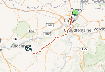
Trail Walking of 61 km to be discovered at Wallonia, Liège, Liège. This trail is proposed by fputters.
Positioning
Country:
Belgium
Region :
Wallonia
Department/Province :
Liège
Municipality :
Liège
Location:
Jupille-sur-Meuse
Start:(Dec)
Start:(UTM)
682822 ; 5614240 (31U) N.
Comments