


Meau-Varrèdes-Congis-Isles

Bernardcom
User
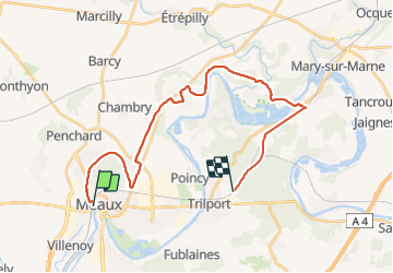

Length
26 km

Max alt
105 m

Uphill gradient
273 m
Km-Effort
29 km

Min alt
46 m

Downhill gradient
249 m
Boucle
No
Creation date :
2021-12-10 09:13:41.098
Updated on :
2021-12-10 15:27:48.106
6h12
Difficulty : Very difficult

FREE GPS app for hiking
 SityTrail
IGN / Geographical institutes
SityTrail Plus
The world is yours!
About
Trail Walking of 26 km to be discovered at Ile-de-France, Seine-et-Marne, Meaux. This trail is proposed by Bernardcom.
Positioning
Country:
France
Region :
Ile-de-France
Department/Province :
Seine-et-Marne
Municipality :
Meaux
Location:
Unknown
Start:(Dec)
Start:(UTM)
490775 ; 5422756 (31U) N.
Comments