


14021042

domifon
User
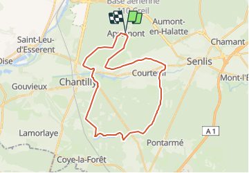

Length
29 km

Max alt
83 m

Uphill gradient
240 m
Km-Effort
32 km

Min alt
39 m

Downhill gradient
241 m
Boucle
Yes
Creation date :
2021-12-11 08:38:19.0
Updated on :
2021-12-11 08:38:19.738

FREE GPS app for hiking
 SityTrail
IGN / Geographical institutes
SityTrail Plus
The world is yours!
About
Trail of 29 km to be discovered at Hauts-de-France, Oise, Apremont. This trail is proposed by domifon.
Positioning
Country:
France
Region :
Hauts-de-France
Department/Province :
Oise
Municipality :
Apremont
Location:
Unknown
Start:(Dec)
Start:(UTM)
464427 ; 5452549 (31U) N.
Comments