


Fresnoy le Château

MoiClaude
User
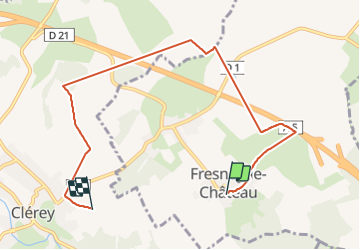

Length
7.2 km

Max alt
149 m

Uphill gradient
77 m
Km-Effort
8.2 km

Min alt
119 m

Downhill gradient
78 m
Boucle
No
Creation date :
2021-12-11 12:36:29.723
Updated on :
2021-12-11 15:36:33.453
41m
Difficulty : Medium

FREE GPS app for hiking
 SityTrail
IGN / Geographical institutes
SityTrail Plus
The world is yours!
About
Trail Walking of 7.2 km to be discovered at Grand Est, Aube, Fresnoy-le-Château. This trail is proposed by MoiClaude.
Description
Rando
Positioning
Country:
France
Region :
Grand Est
Department/Province :
Aube
Municipality :
Fresnoy-le-Château
Location:
Unknown
Start:(Dec)
Start:(UTM)
590889 ; 5340173 (31U) N.
Comments