


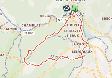
labegude mercuer

raab
User

Length
9.6 km

Max alt
520 m

Uphill gradient
376 m
Km-Effort
14.7 km

Min alt
228 m

Downhill gradient
388 m
Boucle
Yes
Creation date :
2021-12-12 10:10:38.496
Updated on :
2021-12-12 17:31:13.884
3h20
Difficulty : Difficult

FREE GPS app for hiking
 SityTrail
IGN / Geographical institutes
SityTrail Plus
The world is yours!
About
Trail Walking of 9.6 km to be discovered at Auvergne-Rhône-Alpes, Ardèche, Labégude. This trail is proposed by raab.
Positioning
Country:
France
Region :
Auvergne-Rhône-Alpes
Department/Province :
Ardèche
Municipality :
Labégude
Location:
Unknown
Start:(Dec)
Start:(UTM)
608318 ; 4944851 (31T) N.
Comments