


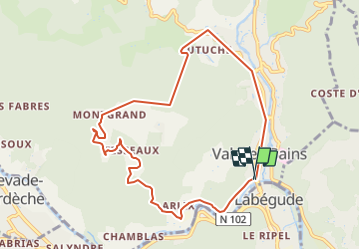
2021-12-12_18h19m44_ignrando_android_export

Linerou
User

Length
9.4 km

Max alt
506 m

Uphill gradient
337 m
Km-Effort
13.9 km

Min alt
235 m

Downhill gradient
341 m
Boucle
Yes
Creation date :
2021-12-12 17:19:44.223
Updated on :
2021-12-12 18:09:13.317
4h05
Difficulty : Difficult

FREE GPS app for hiking
 SityTrail
IGN / Geographical institutes
SityTrail Plus
The world is yours!
About
Trail Walking of 9.4 km to be discovered at Auvergne-Rhône-Alpes, Ardèche, Vals-les-Bains. This trail is proposed by Linerou.
Description
Vals les bains
Positioning
Country:
France
Region :
Auvergne-Rhône-Alpes
Department/Province :
Ardèche
Municipality :
Vals-les-Bains
Location:
Unknown
Start:(Dec)
Start:(UTM)
608202 ; 4945225 (31T) N.
Comments