


echaillon 3

guyzinz
User
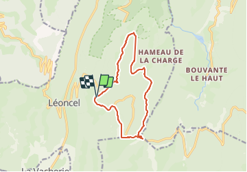

Length
12.9 km

Max alt
1355 m

Uphill gradient
477 m
Km-Effort
19.2 km

Min alt
1039 m

Downhill gradient
470 m
Boucle
Yes
Creation date :
2021-12-13 08:11:15.914
Updated on :
2021-12-13 14:49:13.915
4h16
Difficulty : Very difficult

FREE GPS app for hiking
 SityTrail
IGN / Geographical institutes
SityTrail Plus
The world is yours!
About
Trail Walking of 12.9 km to be discovered at Auvergne-Rhône-Alpes, Drôme, Léoncel. This trail is proposed by guyzinz.
Positioning
Country:
France
Region :
Auvergne-Rhône-Alpes
Department/Province :
Drôme
Municipality :
Léoncel
Location:
Unknown
Start:(Dec)
Start:(UTM)
674364 ; 4975718 (31T) N.
Comments