


a partir de Tampiko

avdem
User

Length
12 km

Max alt
100 m

Uphill gradient
165 m
Km-Effort
14.2 km

Min alt
35 m

Downhill gradient
163 m
Boucle
Yes
Creation date :
2021-12-14 08:05:32.288
Updated on :
2021-12-14 11:09:19.744
2h45
Difficulty : Very easy

FREE GPS app for hiking
 SityTrail
IGN / Geographical institutes
SityTrail Plus
The world is yours!
About
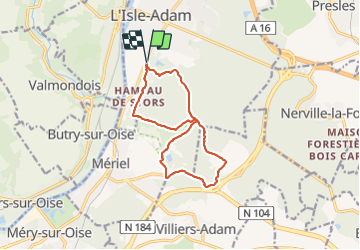
Trail Walking of 12 km to be discovered at Ile-de-France, Val-d'Oise, L'Isle-Adam. This trail is proposed by avdem.
Description
Tres favcile
Positioning
Country:
France
Region :
Ile-de-France
Department/Province :
Val-d'Oise
Municipality :
L'Isle-Adam
Location:
Unknown
Start:(Dec)
Start:(UTM)
442885 ; 5439073 (31U) N.
Comments