


coquin maix par crêtes

Titinechris
User
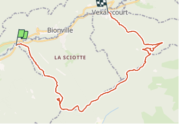

Length
19.4 km

Max alt
825 m

Uphill gradient
690 m
Km-Effort
28 km

Min alt
340 m

Downhill gradient
662 m
Boucle
No
Creation date :
2021-12-15 08:03:27.318
Updated on :
2021-12-15 11:45:21.247
3h41
Difficulty : Easy

FREE GPS app for hiking
 SityTrail
IGN / Geographical institutes
SityTrail Plus
The world is yours!
About
Trail Trail of 19.4 km to be discovered at Grand Est, Vosges, Celles-sur-Plaine. This trail is proposed by Titinechris.
Positioning
Country:
France
Region :
Grand Est
Department/Province :
Vosges
Municipality :
Celles-sur-Plaine
Location:
Unknown
Start:(Dec)
Start:(UTM)
350810 ; 5371359 (32U) N.
Comments