


SityTrail - 3023306 - montelimar-le-gery-11km

thonyc
User GUIDE
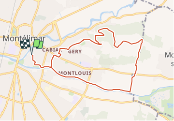

Length
10.4 km

Max alt
167 m

Uphill gradient
137 m
Km-Effort
12.3 km

Min alt
83 m

Downhill gradient
137 m
Boucle
Yes
Creation date :
2021-12-15 14:22:34.696
Updated on :
2023-06-08 07:53:35.407
2h47
Difficulty : Easy

FREE GPS app for hiking
 SityTrail
IGN / Geographical institutes
SityTrail Plus
The world is yours!
About
Trail Walking of 10.4 km to be discovered at Auvergne-Rhône-Alpes, Drôme, Montélimar. This trail is proposed by thonyc.
Positioning
Country:
France
Region :
Auvergne-Rhône-Alpes
Department/Province :
Drôme
Municipality :
Montélimar
Location:
Unknown
Start:(Dec)
Start:(UTM)
639252 ; 4934862 (31T) N.
Comments