


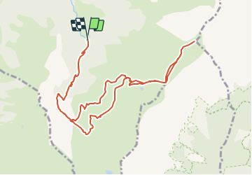
SityTrail - Pointe de Mandallaz

UDGI54
User

Length
12.4 km

Max alt
2246 m

Uphill gradient
1078 m
Km-Effort
27 km

Min alt
1181 m

Downhill gradient
1076 m
Boucle
Yes
Creation date :
2021-12-15 17:21:30.232
Updated on :
2021-12-15 17:21:30.232

FREE GPS app for hiking
 SityTrail
IGN / Geographical institutes
SityTrail Plus
The world is yours!
About
Trail of 12.4 km to be discovered at Auvergne-Rhône-Alpes, Upper Savoy, Manigod. This trail is proposed by UDGI54.
Positioning
Country:
France
Region :
Auvergne-Rhône-Alpes
Department/Province :
Upper Savoy
Municipality :
Manigod
Location:
Unknown
Start:(Dec)
Start:(UTM)
299415 ; 5078576 (32T) N.
Comments