


16

Divio
User

Length
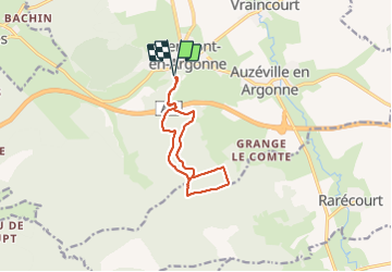
9.7 km

Max alt
306 m

Uphill gradient
231 m
Km-Effort
12.8 km

Min alt
219 m

Downhill gradient
232 m
Boucle
Yes
Creation date :
2021-12-16 07:57:45.65
Updated on :
2021-12-16 10:14:11.843
2h16
Difficulty : Very easy

FREE GPS app for hiking
 SityTrail
IGN / Geographical institutes
SityTrail Plus
The world is yours!
About
Trail Nordic walking of 9.7 km to be discovered at Grand Est, Meuse, Clermont-en-Argonne. This trail is proposed by Divio.
Positioning
Country:
France
Region :
Grand Est
Department/Province :
Meuse
Municipality :
Clermont-en-Argonne
Location:
Unknown
Start:(Dec)
Start:(UTM)
650881 ; 5440889 (31U) N.
Comments