


guip

natsukeru
User
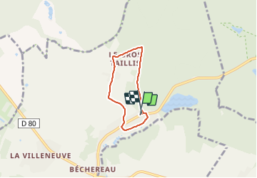

Length
4 km

Max alt
180 m

Uphill gradient
58 m
Km-Effort
4.8 km

Min alt
132 m

Downhill gradient
54 m
Boucle
Yes
Creation date :
2021-12-16 13:58:31.398
Updated on :
2021-12-16 14:27:22.489
28m
Difficulty : Very easy

FREE GPS app for hiking
 SityTrail
IGN / Geographical institutes
SityTrail Plus
The world is yours!
About
Trail Running of 4 km to be discovered at Ile-de-France, Yvelines, Hermeray. This trail is proposed by natsukeru.
Positioning
Country:
France
Region :
Ile-de-France
Department/Province :
Yvelines
Municipality :
Hermeray
Location:
Unknown
Start:(Dec)
Start:(UTM)
404236 ; 5390518 (31U) N.
Comments