


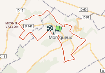
Montgueux

MoiClaude
User

Length
10.3 km

Max alt
267 m

Uphill gradient
229 m
Km-Effort
13.3 km

Min alt
173 m

Downhill gradient
229 m
Boucle
Yes
Creation date :
2021-12-16 13:08:27.498
Updated on :
2021-12-16 15:49:25.775
2h20
Difficulty : Difficult

FREE GPS app for hiking
 SityTrail
IGN / Geographical institutes
SityTrail Plus
The world is yours!
About
Trail Walking of 10.3 km to be discovered at Grand Est, Aube, Montgueux. This trail is proposed by MoiClaude.
Positioning
Country:
France
Region :
Grand Est
Department/Province :
Aube
Municipality :
Montgueux
Location:
Unknown
Start:(Dec)
Start:(UTM)
570750 ; 5350773 (31U) N.
Comments